KGeography 23.04.3 Description:
KGeography combines the power of technology with the beauty of maps to make learning geography fun and engaging. Whether you're a student, a teacher, or simply someone who loves to explore the world, this innovative tool is a must-have in your educational arsenal.
Introduction to KGeography and its Features
KGeography is an open-source tool specifically designed for Linux users so there are no KGeography for windows version, KGeography provides an innovative and interactive way to learn about different countries, capitals, and geographical features.
With KGeography, you can explore the world at your own pace and gain a deeper understanding of our planet's diverse landscapes. The software offers a wide range of quizzes and games that make learning geography both fun and engaging. Whether you're a student or simply someone who enjoys expanding their knowledge, KGeography is the perfect tool to enhance your geographical skills.
KGeography is free to use but also constantly evolving through community contributions. This ensures that the software remains up-to-date with new information and features. Additionally, being open-source promotes collaboration among users, allowing for customization and personalization based on individual preferences.
Using KGeography, You'll find yourself immersed in interactive maps, quizzes, and challenges that will test your knowledge while providing an enjoyable learning experience.
Discover the Power of Interactive Maps and Quizzes
KGeography software brings geography to life through its interactive maps and engaging quiz mode. Whether you're a student, educator, or simply someone who loves exploring the world, KGeography offers a unique and fun way to enhance your geographical knowledge.
You can dive into various geographical quizzes right from the comfort of your Linux device. Test your knowledge on continents, countries, capitals, mountains, rivers, and so much more. The quiz mode challenges you with questions that will not only expand your understanding but also keep you thoroughly entertained.
KGeography's quiz mode allows you to actively engage with the subject matter. By answering questions and receiving instant feedback on your performance, you can identify areas for improvement and focus on specific topics that require attention.
You can explore continents and countries in detail by zooming in or out, discovering their political boundaries or geographical features. This hands-on approach makes learning geography more immersive and memorable.
KGeography offers a comprehensive platform for creating customized quizzes effortlessly.
Learn About Countries, Capitals, Flags, and More
Discover the extraordinary world of KGeography, where learning about countries and their capital cities becomes a captivating journey. With its innovative features, KGeography is transforming the way we explore geography and expand our knowledge of different nations.
One of the standout features of KGeography is its comprehensive country information database. Whether you're a student or just someone eager to broaden their horizons, this tool provides you with in-depth information about each country's history, culture, economy, and much more. Gone are the days of flipping through countless books or scouring the internet for reliable sources - KGeography has all the information you need at your fingertips.
KGeography takes learning to another level by incorporating interactive quizzes that test your knowledge of capital cities. No more rote memorization or tedious flashcards - simply dive into the immersive world of KGeography and challenge yourself with engaging quizzes that make learning fun and exciting.
As you navigate through various countries, you can develop an eye for recognizing different flags and understanding their symbolism. This visual aspect not only enhances your learning experience but also helps you retain information effortlessly.
KGeography saves time by providing all-encompassing country information in one place while making learning enjoyable through interactive quizzes and flag recognition activities.
Key Features of KGeography
KGeography comes packed with a wide range of features that make it an exceptional tool for learning geography. The software provides detailed maps of the world, continents, and countries, allowing users to explore and learn about different regions. The maps are interactive, enabling users to zoom in and out, pan, and click on specific areas to gather more information. Additionally, KGeography includes various overlays, such as political borders, physical features, and cultural landmarks, to enhance the learning experience.
One of the standout features of KGeography is its interactive quizzes and games. Users can test their knowledge of countries, capitals, flags, and more through engaging quizzes that challenge their understanding. The quizzes are customizable, allowing users to focus on specific regions or topics. This gamified approach to learning makes studying geography enjoyable and helps reinforce knowledge in a fun and interactive way.
Another noteworthy feature of KGeography is its extensive customization options. Users can personalize their learning experience by choosing from different map styles, adjusting the difficulty level of quizzes, and modifying the types of questions asked. This flexibility ensures that KGeography caters to individual learning preferences and adapts to users of all ages and knowledge levels.
Expand Your Knowledge with Detailed Statistics and Facts
Whether you're a student, researcher, or simply an enthusiast, this powerful application will revolutionize the way you explore and understand our planet. Get ready to embark on an exciting journey of discovery with KGeography!
Customize Your Learning Experience with Multiple Language Support and Themes
KGeography not only offers an array of features to enhance your geographic knowledge, but it also provides robust language support options and theme customization to cater to users worldwide.
One of the standout features of KGeography is its ability to support multiple languages. Whether you prefer English, Spanish, French, or any other language, KGeography has got you covered. With just a few clicks, you can easily switch between different language options and explore the world in your preferred language. This feature ensures that users from diverse linguistic backgrounds can fully enjoy and engage with the software.
You can choose from various themes or even create your own personalized theme by adjusting colors, fonts, and layouts. This level of customization ensures that each user can create a visually appealing environment that suits their individual style.
Built specifically for Linux operating systems, KGeography seamlessly integrates with your system and takes full advantage of its capabilities. It is designed with efficiency in mind, ensuring smooth performance and optimal resource utilization on your Linux machine.
The Best Resources to Get Started with KGeography on Your Linux System
Whether you're a student, teacher, or simply an avid learner, KGeoegraphy offers a seamless and engaging experience that will expand your knowledge of the world.
To ensure you make the most out of this powerful tool, the KGeoegraphy user guide serves as your comprehensive companion. This guide walks you through every aspect of using KGeoegraphy, from navigating its intuitive interface to leveraging its advanced features.
Using KGeography for educational purposes
KGeography is not only a valuable tool for individual learners but also an excellent resource for educators. The software provides teachers with a comprehensive platform to teach geography in a dynamic and interactive way. By incorporating KGeography into their lessons, educators can engage students, encourage active learning, and foster a deeper understanding of global geography.
Teachers can utilize KGeography's interactive quizzes and games to assess students' knowledge, reinforce concepts, and encourage critical thinking. The customizable quizzes allow teachers to tailor assessments to students' specific learning needs, providing targeted feedback and support. This individualized approach to assessment ensures that each student receives the necessary guidance to succeed in their geographical learning.
Moreover, KGeography's detailed maps and overlays can be used as visual aids during lessons. Teachers can project the maps onto a screen or interactive whiteboard, allowing students to explore and analyze different regions together. The interactive nature of KGeography encourages collaboration and discussion, fostering a rich and engaging classroom environment.
KGeography also provides teachers with the ability to track students' progress and performance. The software records students' quiz results, allowing teachers to monitor individual and class-wide achievements. This data can be used to identify areas where students may need additional support or to recognize outstanding performance. By leveraging this information, teachers can provide targeted feedback and tailor their instruction to address students' specific needs.
Navigating the KGeography interface
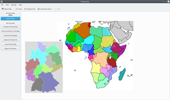
The KGeography interface is designed to be user-friendly and intuitive, making it easy for users to navigate and explore the world. When you first launch KGeography, you'll be greeted with a world map that you can interact with. The map is divided into continents, which can be selected by clicking on them.To explore a specific country or region, simply click on the desired area on the map. This action will zoom in and provide a more detailed view of the selected region. You can pan across the map by clicking and dragging, allowing you to explore different areas of the world.
KGeography provides additional information about countries and regions through overlays. These overlays can be toggled on or off to display political borders, physical features, cultural landmarks, and more. By enabling these overlays, users can gain a deeper understanding of the geographical characteristics and cultural significance of different regions.
The interface also includes a sidebar that provides access to various features and options. From here, users can access quizzes, customize their learning experience, and view additional information about countries, such as their capital cities and flags. The sidebar makes it easy to navigate between different features and ensures a seamless learning experience.
Exploring different regions with KGeography
KGeography allows users to explore and learn about different regions of the world in a captivating and immersive way. By selecting a specific continent or country on the map, users can delve into the unique characteristics, landmarks, and cultures of that region.
For example, if you're interested in learning about Europe, simply click on the European continent on the map. This action will zoom in, providing a detailed view of Europe. From here, you can explore individual countries within Europe, such as France, Germany, or Italy. KGeography provides information about each country's capital city, flag, and other notable features, allowing users to deepen their knowledge about the region.
Similarly, users can explore other continents, such as Asia, Africa, or North America, to discover the diverse landscapes, landmarks, and cultures that make our world so fascinating. KGeography's detailed maps and overlays provide a rich visual experience, enabling users to immerse themselves in the exploration of different regions.
Conclusion
To conclude KGeography works on Linux operating system and can be easily downloaded using the below download link according to GPLv2 license. The download file is only 100 MB in size.KGeography was filed under the Document category and was reviewed in softlookup.com and receive 5/5 Score.
KGeography has been tested by our team against viruses, spyware, adware, trojan, backdoors and was found to be 100% clean. We will recheck KGeography when updated to assure that it remains clean.
KGeography user Review
Please review KGeography application and submit your comments below. We will collect all comments in an effort to determine whether the KGeography software is reliable, perform as expected and deliver the promised features and functionalities.Popularity 10/10 - Downloads - 200 - Score - 5/5
| Category: | Document |
| Publisher: | Albert Astals Cid |
| Last Updated: | 10/12/2023 |
| Requirements: | Enterprise Linux 9 (CentOS 9, RHEL 9, Rocky Linux 9, AlmaLinux 9) EPEL x86_64 |
| License: | GPLv2 |
| Operating system: | Linux |
| Hits: | 1906 |
| File size: | 100 MB |
| Price: | Not specified |
 |
 |
| Name: * |
E-Mail: * |
| Comment: * |
|